UPPER NAPPAN, N.S. — Who closes the marsh separating Amherst and Sackville and under what conditions is something Cumberland County’s EMO co-ordinator wants to clarify with Transportation officials on both sides of the Nova Scotia-New Brunswick border.
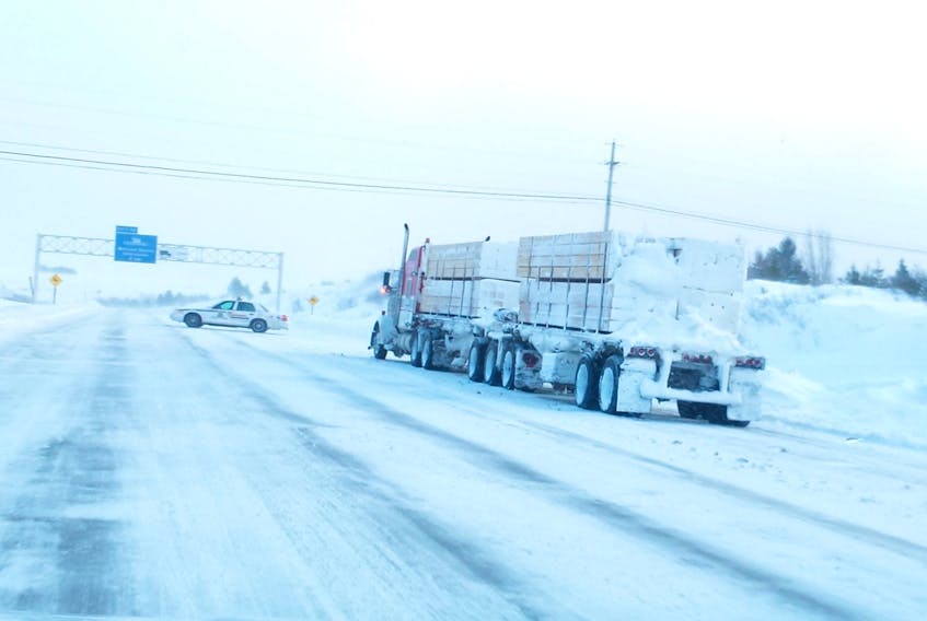
Speaking to Cumberland municipal council on Nov. 27, Mike Johnson said there have been several closures of the Trans-Canada Highway across the Tantramar in recent years due to high winds and/or decreased visibility with Nov. 1 being the latest example, during which southwest winds of 80 to 90 km/h closed the highway for several hours backing up trucks in Amherst and Sackville as well as in Aulac, N.B.
“Right now there’s nothing place that provides us with fixed thresholds for wind or visibility that would trigger a contingency plan that says the RCMP will do this and the Transportation Department will do this, the fire department will do this, or Amherst will do this,” Johnson said. “These things do happen, but they happen as a matter of all of a sudden when we have to respond to these situations.”
Council has agreed to send a letter to the Nova Scotia Transportation and Infrastructure Renewal Department, the Town of Amherst, both of Cumberland County’s MLAs as well as to others on the New Brunswick side, including the Town of Sackville, to set up a working group to come up with a contingency plan that would determine how the marsh is closed to traffic during hazardous weather conditions.
This working group, he said, should include RCMP in both provinces along with fire departments and EHS and both transportation departments, along with EMO.
“It should include all the people who would respond should the need arise to close the highway,” he said. “The agency of jurisdiction is the Department of Transportation, but when something happens, they’re not necessarily the agency that responds. It’s the police, fire and EHS that go out. They (Transportation) are the ones that make the decision to close the marsh, but we have a work environment out there that can become a hazardous work environment for these first responders and we’re trying to find a way to mitigate the potential for not only the travelling public but also first responders on the Tantramar Marsh.”
Marla MacInnis from Transportation and Infrastructure Renewal said Friday the decision to close the highway on Nov. 1 was “made based on the observed conditions and forecasted sustained winds and gusts.”
MacInnis said when the highway needs to be closed TIR requires assistance from the RCMP and local police.
“This co-ordination between NSTIR, first responders and local EMO is essential to close the highway safely and manage affected traffic,” she said in an email to the Amherst News.
When the closure occurred, police and EMO were notified as were TIR operations and 511 while the variable message boards at Debert was updated and traffic was rerouted at the inbound scales in Fort Lawrence and Exit 4 (South Albion Street) in Amherst.
Amherst Police and RCMP assisted with direction for parking of high-sided vehicles and parked vehicles were notified once the decision was made to reopen the highway.
Johnson told council the marsh is a unique geographical area with multi-jurisdictional control and multiple agency responsibilities from two provinces. From meetings, Johnson said, everyone is operating from a diversified set of situational perspectives. – and they are inherently different due to political, administrative and operational natures within Nova Scotia and New Brunswick.
“We have observed weather conditions on the Tantramar Marsh that result in zero visibility and extreme winds that blow vehicles over,” he said. “One could argue that these same conditions can exist in either jurisdiction and that is true, however on the Tantramar Marsh these conditions frequently occur when they exist in no other location adjacent to the marsh.”
Similar to how a sign warns motorists of a hazard that doesn’t exist normally, like a bump or water on the road, Johnson said the same is true for travellers when it comes to unusual weather conditions.
“If we presently put signs and cones up to warn vehicle operators of a hazard that is likely to cause damage to the vehicle or loss of control, it is equally important, if not more, to warn of a hazard that could lead to injury or death,” the EMO co-ordinator said.
Johnson said stakeholders met following a February 2015 closure to develop contingency plans that provided clear thresholds, roles and responsibilities when weather conditions warrant the closure of the highway across the marsh.
The EMO co-ordinator said Nova Scotia’s Transportation and Infrastructure Renewal Department did not adopt those thresholds identified in the contingency plan and he said the plan is also not being followed by New Brunswick.
“All being said, this leaves us without a planned operational response to the hazardous weather conditions unique to the Tantramar Marsh,” Johnson said.
Johnson said any plan should include historical wind and visibility values that threaten safe travel across the marsh. An escalating measured approach that is tied to the criteria that threatens safe travel would be the best way to go, he said, given the public will have a variety of opinions that are for and against closing the highway.
“We need to the know that when the wind hits X speed it’s a threat to public safety crossing the marsh and we need to close it,” he said. “When it gets to a certain speed we’re going to restrict high-sided vehicles from crossing, when it get to another speed we’re going to restrict things like vans or SUVs and when it gets to say, 115 or 120 km/h, we’re going to restrict all traffic. For visibility, we could say when it’s reduced to 400 metres it’s time to close the marsh because of the potential consequences that could happen.”